File:Eastern Kingdoms concept sketch.jpg
Jump to navigation
Jump to search


Size of this preview: 463 × 600 pixels. Other resolutions: 185 × 240 pixels | 1,080 × 1,399 pixels.
Original file (1,080 × 1,399 pixels, file size: 701 KB, MIME type: image/jpeg)
Summary
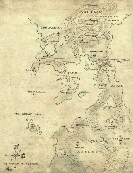
Very early Eastern Kingdoms map by Chris Metzen (1995) as seen in the World of Warcraft Collector's Edition pack. It depicts interesting details considering it was originally a rough map for World of Warcraft.
- Quel'Thalas:
- Silvermoon
- Kalvanost
- Horad
- Northeron
- Dun Kithas (see Dun)
- Lordaeron:
- Tirisfaen Fields
- New Moonbrook (most probably a Stormwindian refuge/settlement named after Moonbrook)
- Darrowmere
- Stratholme
- Tyr's Hand
- Alterac
- Dalaran
- Gel Nor
- Hillsbrad
- Southshore
- Gilneas
- Stromgarde
- Tirisfaen Fields
- Khaz Modan:
- Thandol Valley Dam
- Dun Modr
- Dun Algaz (being at the location of Dun Modr, like in Warcraft II)
- Badlands
- Thandol Valley Dam
Licensing
This image is concept art officially recognized by Blizzard.
Sources
- Source (early sketch)
- BlizzConline - Warcraft Art Gallery
File history
Click on a date/time to view the file as it appeared at that time.
| Date/Time | Thumbnail | Dimensions | User | Comment | |
|---|---|---|---|---|---|
| current | 18:27, 5 October 2023 | | 1,080 × 1,399 (701 KB) | Mrforesttroll (talk | contribs) | == Summary == image from page info from - https://m.artgallery.blizzcon.com/warcraft |
| 14:05, 20 February 2021 | 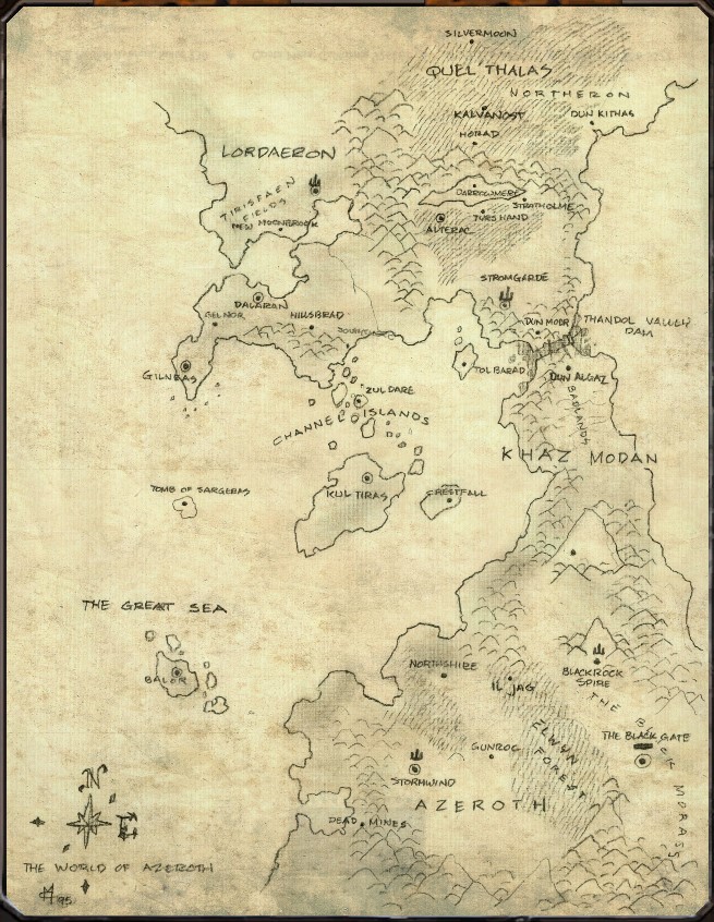 | 655 × 846 (209 KB) | Mordecay (talk | contribs) | ||
| 03:27, 22 December 2007 |  | 428 × 562 (60 KB) | Curse1 (talk | contribs) | == Summary == Rough sketches of EK done during WoW development. Notice Kul'Tiras and Quel'Thalas, Northeron, and Gilneas.[http://www.zaphoyd.com/wowcemaps/web-Pages/Image2.html] |
You cannot overwrite this file.
File usage
The following 12 pages use this file: