Talk:Dragonblight
Captions
Can we get some map captions please?
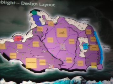
- It is not possible to really caption a Dragonblight map since every screenshot I have seen is of horrible quality. Though one area is clear and that is a Scourge Excavation site. Whats also known is that there will be shrines for every flight in the Dragonblight. And by the looks of what I can make out Wyrmrest Temple is the neutral town in the center of the map. Also sign your comments. Leviathon 20:45, 20 September 2007 (UTC)
- Help me with the captions, I got two maps, you can see "Coastal Fortress" among others. -- Shandris talk / contribs 09:11, 21 September 2007 (UTC)
- Nice job Shandris actual pictures that are not so fuzzy they kill my eyes :p I cannot see Bloodmar Village anywhere. Sundered Monolith could possibly be the most northern neutral town which is un-named. Icemist Village is either the horde town or not even part of WotLK's Dragonblight and actually the horde base in the PVP zone since mountains block off a lot of areas in WotLK that are not in the RPG map such as the only way to Icecrown on the WotLK map is through Storm Peaks.
- The neutral town at the south is labeled as Tuskar Village
- The smaller square to the east of coastal fortress is Shrine of the Blue Dragonflight
- The white text there also says Wooded Area
- The yellow square north of the Wooded Area text is Shrine of the Green Dragonflight
- The yellow square east of the Tuskar Village is Shrine of the Black Dragonflight
- The central neutral town is Wyrmrest Temple (so it's not a instance)
- The green dot says Azjol-Nerub entrance
- The red square area is the horde base and blue square is the alliance base. Both bases names I cannot make out.
- The yellow square north of the alliance base by the mountains is another shrine but can't make out what flight though it looks like Bronze
- The yellow square south of Azjol'Nerub is another shrine and looks like the Red Dragonflight
- The yellow square northwest of Wyrmrest Temple is labeled as Dragon Bones same thing with the yellow square northeast of Wyrmrest Temple
- Some areas I cannot make out the full names are: Southwest of the yellow square under Azjol'Nerub is the Village of something. The yellow square west of the coastal fortress is the Camp of something. Leviathon 17:25, 21 September 2007 (UTC)
- Well the Tuskarr village on the coast is named Moa’ki Harbor according to the new Tuskarr page. http://www.worldofwarcraft.com/wrath/features/factions/tuskarr.xml Leviathon 19:58, 21 February 2008 (UTC)
- the shrine of the red dragonflight is named ruby dragonshrine as can be seen on this picture: http://www.worldofwarcraft.com/wrath/images/artwork/ss34.jpg
Official updates
[1]. It's crazy-go nuts. Scarlet Onslaught! Scourge invasions of the dragon shrines! Angrathar the Wrathgate, barred entrance to Icecrown! Malygos' crazy-go nuts machinations! Neat stuff. --k_d3 18:33, 13 March 2008 (UTC)
- That Scarlet Onslaught town sure looks massive from that video. Looks like another reason was given for us to go after Malygos also. Leviathon 20:23, 13 March 2008 (UTC)
Zone Design Layout
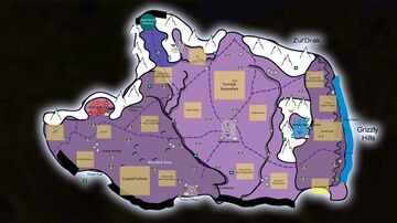
Since it seems Shandris never got the time to re-do the image from Blizzcon I decided to take some time to do it. I added all the captions I could make out though I did just assume the northern most neutral town was Sundered Monolith since its so close to Azjol'Nerub. With the recent Dragonblight page from Blizzard also I am not sure if the green dot (which normally means a instance) is still the entrance to Azjol-Nerub or if thats the Angrathar Gate to Icecrown (Since it seems like that when you look at the larger map from Blizzcon) with Azjol-Nerub being the exit to the east of that. If anyone can make out any other captions I will add them or if theres anything anyone feels needs to be changed. One thing I may add to the image are the green squares that are all over the map which I would assume are the machines Malygos placed all over the zone. Leviathon 02:36, 22 March 2008 (UTC)
- Looks good, but the white text on beige background is awkward and hard to read. Try black? ----
 Varghedin talk / contribs 11:44, 23 March 2008 (UTC)
- Try to follow my style Levi; did you use Photoshop? -- Shandris talk / contribs 15:47, 23 March 2008 (UTC)
Ended up changing the text to black also since after looking at it I am not sure why I did white. I did use Photoshop but I had to re-do some parts of the image myself such as the roads since the quality of the Dragonblight and Howling Fjord images were horrible compared to Grizzly Hills and Borean Tundra. I did want to get a hold of you though Shandris to find out what font size/type you used. The way your images look like just sharper images of the original image is nice but a bit beyond what I know how to do in Photoshop. Find it funny how I had a easier time doing the Howling Fjord image considering how bad its quality was. Leviathon 21:13, 23 March 2008 (UTC)
- A tip, I used 90% Illustrator to make the map, and Photoshop for the finishing touches. Illustrator is an awesome tool. Fonts used, Friz Quadrata TT in the Grizzly Hills map, and I think Myndraine in the Borean Tundra map; what font looks best you think?
- P.S. I'm on my way to make a Dragonblight map but it takes years to make and oftentimes I can't be arsed to sit down and draw....
- And concerning the background image, it's a snapshot from the DVD I got in Collector's Edition of World of Warcraft, portraying the Frozen Throne (finale cinematic from Warcraft III: The Frozen Throne). -- Shandris talk / contribs 11:29, 25 March 2008 (UTC)
- I'm not taking action yet, cos i'm hoping this can be resolved. Leviaton, you're very clearly using alpha info for your new version and sneaking it in with image edits is not okay. I suggest this gets reverted back so we have a version that matches what was shown at blizzcon only. If it's not done, the image needs to go. I could also point how alot of the labels are wrong, but it's pointless. -- Zeal (T/C) 18:54, 25 May 2008 (UTC)
- Tough position, cos i have to dance around the rules with what i say. Knowing certain things have changed from what was suggested the first time round (the new suggestions not matching what is on the blizzcon map as far as i can tell), the updates all being made since access to the information became more widely available. Hard to beleive it's multiple coincidences. What i will say is though, alot of things have moved around to unexpected results, and thats why i noticed this. -- Zeal (T/C) 19:27, 25 May 2008 (UTC)
- Personally, i prefer your vectored maps for this sorta thing Shandris, so hopefully you get round to this one before it comes superfluous. Rasterize image edited maps just aren't as crisp or clean to view, also harder to readjust and update. -- Zeal (T/C) 19:32, 25 May 2008 (UTC)
- The current version, at least, looks very much like the BlizzCon map. I'm not sure what Alpha info was slipped in there. -- Dark T Zeratul (talk) 19:43, 25 May 2008 (UTC)
- Personally, i prefer your vectored maps for this sorta thing Shandris, so hopefully you get round to this one before it comes superfluous. Rasterize image edited maps just aren't as crisp or clean to view, also harder to readjust and update. -- Zeal (T/C) 19:32, 25 May 2008 (UTC)
- It's mainly the switching around of AN and Angrathar, though i'm not saying if that's right or wrong. I just fail to see how someone without alpha knowledge could even think of that idea. Existing lore doesn't suggest AN would be to the east (it points to it being in Angrathar's position or north of it) and the label on the Blizzcon map is definitely not Angrathar. If it's not alpha informed, then i apologize for that. But either way, it seems silly to be adding speculative labels and changing away from the more probable labels people are making out from the photos. -- Zeal (T/C) 00:13, 26 May 2008 (UTC)
I never edited the image ever since the day I originally uploaded it and that was back in March and the Alpha began last week so theres no way I could of added Alpha info. I did guess on the location of the Wrathgate and Azjol-Nerub entrance (and some other names like Icemist Village). Of the 4 zones Blizzard showed concept maps of Dragonblight has changed a lot. Leviathon (talk) 01:54, 31 May 2008 (UTC)
dragons?
i have seen bones of two really big dragons lying at the bottom of the sea near the end of the really big road any idea of who the dragon were???user:billylj
- The Dragonblight is where all dragons have gone to die for the last ten thousand years and then some. Most of the dragon bones there belong to unknown dragons. -- Dark T Zeratul (talk) 18:49, March 5, 2010 (UTC)
- yeah i know but that was a really big dragon he/she was bigger than alexstrasza klick on this [2] see him/she user:billylj


