File:Eastern Kingdoms pre-WoW 1.jpg
Eastern_Kingdoms_pre-WoW_1.jpg (450 × 574 pixels, file size: 81 KB, MIME type: image/jpeg)
Summary
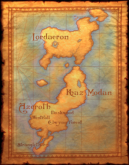
Map of the Eastern Kingdoms from The World of Warcraft Townhall.
An updated map was used for Computer Gaming World 2001 article. That version also names Quel'Thalas, Aerie Peak, Alterac Mountains, Tol Barad, Kul Tiras, Grim Batol, Blackrock Spire, and the correct order of the Westfall, Elwynn Forest, and Duskwood zones.
Source
An early map of the Eastern Kingdoms, used on the website www.blizzard.com[1] in 2003 under the filename "wowmap.jpg".
Notes
This article or section includes speculation, observations or opinions possibly supported by lore or by Blizzard officials. It should not be taken as representing official lore.
|
This is possibly the first Eastern Kingdoms-map which is directly linked to World of Warcraft (rather than to the entire Warcraft-universe in general).
References
- ^ https://web.archive.org/web/20030609105136/http://blizzard.com:80/wow/townhall/worldmap.shtml | Web title=World of Warcraft - World Map | Publisher=Blizzard Entertainment | Date posted=Unknown | Date displayed=Feb 2, 2003 | Date referenced=May 25, 2012 (accessed through Internet Archive: Wayback Machine: link. The earliest display-date has been chosen for this reference.)
Licensing
| This image is copyrighted to Blizzard Entertainment Inc. |
|---|
| However: |
| Blizzard Entertainment Inc. grants "a personal, non-exclusive, non-transferable and non- assignable license to use and display, for home, noncommercial and personal use only, one copy of any material and/or software that you may download from [their] site, including, but not limited to, any files, codes, audio or images incorporated in or generated by the software (collectively the "Downloaded Content") provided, however, that you must include or maintain all copyright and other notices contained or associated with such Downloaded Content." |
Furthermore, we believe this falls under American fair use law because:
|
File history
Click on a date/time to view the file as it appeared at that time.
| Date/Time | Thumbnail | Dimensions | User | Comment | |
|---|---|---|---|---|---|
| current | 08:02, 5 October 2023 | | 450 × 574 (81 KB) | Mrforesttroll (talk | contribs) | == Summary == https://web.archive.org/web/20030609105136/http://blizzard.com:80/wow/townhall/worldmap.shtml |
You cannot overwrite this file.
File usage
The following 7 pages use this file: